


Handy GPS lite

Handy GPS lite의 설명
다음 아웃도어 모험을 위한 완벽한 동반자입니다. Handy GPS로 찾고, 찾고, 기록하고 집으로 돌아갑니다. 사용자 계정이나 설정이 필요하지 않습니다. 설치하고 GPS를 켜기만 하면 됩니다!
이 앱은 하이킹, 부시워킹, 트램핑, 산악자전거, 카약, 승마, 지오캐싱과 같은 야외 스포츠를 위해 설계된 강력한 탐색 도구입니다. 측량, 광업, 고고학 및 임업 응용 프로그램에도 유용합니다. 네트워크 연결이 필요하지 않기 때문에 사용이 간편하고 가장 먼 오지에서도 작동합니다. UTM 또는 위도/경도 좌표로 작업할 수 있으므로 종이 지형도에서도 사용할 수 있습니다.
참고: 이것은 무료 평가판이며 3개의 웨이포인트와 40개의 트랙 로그 포인트만 저장할 수 있습니다. 평가판은 원하는 기간 동안 사용할 수 있지만 이 앱이 마음에 드신다면 "Handy GPS"의 유료 버전을 설치하여 더 많은 기능이 포함된 무제한 버전을 얻으십시오. 감사해요!
또한 앱이 항상 GPS를 사용하도록 허용하고 휴대폰 화면이 꺼져 있을 때 앱이 트랙 로그를 안정적으로 기록하도록 배터리 최적화를 끕니다.
기본 기능:
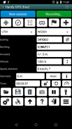
* 현재 좌표, 고도, 속도, 이동 방향, 미터법, 제국/미국 또는 해상 단위로 이동한 총 거리를 표시합니다.
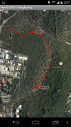
* 현재 위치를 웨이포인트로 저장하고 트랙 로그를 기록하여 지도에 있었던 위치를 표시할 수 있습니다.
* 데이터는 KML 및 GPX 파일에서 가져오고 내보낼 수 있습니다.
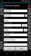
* UTM, MGRS 및 위도/경도 좌표에서 웨이포인트를 수동으로 입력할 수 있습니다.
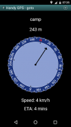
* "Goto" 화면을 사용하여 웨이포인트로 안내할 수 있으며, 가까워지면 선택적으로 경고음이 울립니다.
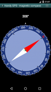
* 자기장 센서가 있는 장치에서 작동하는 나침반 페이지가 있습니다.
* 고도 정확도를 향상시키기 위해 로컬 지오이드 오프셋을 자동으로 계산합니다.
* 일반적인 호주 데이텀 및 지도 그리드와 함께 전 세계 WGS84 데이텀을 지원합니다. 미국에서는 NAD83 지도에 WGS84를 사용할 수 있습니다.
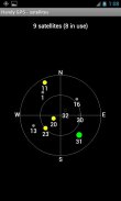
* GPS 위성 위치와 신호 강도를 그래픽으로 표시합니다.
* 단순 또는 MGRS 그리드 참조를 표시할 수 있습니다.
* 중간 지점 간 거리와 방향을 계산할 수 있습니다.
* 걷는 시간을 기록하고 평균 속도를 계산하는 옵션 타이머 라인을 포함합니다.
* 많은 오프 트랙 산책에서 개발자가 철저히 테스트했습니다.
유료 버전에서만 제공되는 추가 기능:
* 광고 없음.
* 웨이포인트와 로그 포인트를 무제한으로 추적할 수 있습니다.
* 오프라인 지도.
* 커스텀 데이텀.
* 고도 프로필.
* 앱에서 사진을 찍고 음성 메모를 녹음하세요.
* 친구에게 위치를 이메일 또는 SMS로 보내십시오.
* 영국 그리드 심판.
* 위치 정확도를 개선하기 위한 GPS 평균화,
* 해가 뜨고 지는 시간.
* 웨이포인트 및 트랙 로그를 CSV 파일로 내보냅니다.
* 방향과 거리를 사용하여 중간 지점을 투사합니다.
* 트랙 로그에서 길이, 면적 및 고도 변화를 계산합니다.
* 칼로리를 계산합니다.
권한: (1) GPS - 위치 확인, (2) 네트워크 액세스 - 표준 지도 레이어 및 OSM 타일 액세스, (3) SD 카드 액세스 - 웨이포인트 및 트랙 로그 로드 및 저장, (4) 촬영을 위한 카메라 액세스 사진*, (5) 근접 알람이 작동하도록 휴대폰이 잠자지 않도록 방지, (6) 앱 내에서 손전등을 켜고 끌 수 있도록 손전등 제어, (7) 음성 메모를 위해 오디오 녹음*. (* 앱의 전체 버전에서만 사용할 수 있는 기능).
면책 조항: 귀하는 이 앱을 자신의 책임 하에 사용합니다. 개발자는 이 앱을 사용한 결과로 인한 분실 또는 부상에 대해 책임을 지지 않습니다. 모바일 장치의 배터리는 소진될 수 있습니다. 장거리 및 원격 하이킹의 경우 안전을 위해 배터리 뱅크와 종이 지도 및 나침반과 같은 대체 탐색 방법을 권장합니다.
Handy GPS lite - 버전 42.8
(21-11-2024)
Handy GPS lite - APK 정보
APK 버전: 42.8패키지: binaryearth.handygpsfreeHandy GPS lite의 최신 버전
다른 버전들


동일 카테고리의 앱


